Save this image free of charge
in 800 pixels for layout use
(right click, Save as...)
|
|
Ref : T01234
Theme :
Looking at Earth - Sea - Coast - Capes - Peninsula (601 images)
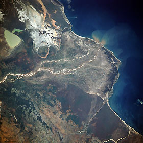
Title : Mangoky River Delta, Madagascar November 1989
Caption :
This low-oblique, southwest-looking photograph reveals the delta of the Mangoky River and the surrounding coastal plain. The Mangoky River is 350 miles (564 kilometers) long and rises in the Central Highlands of Madagascar just east of the city of Fianarantsoa. The river flows generally in a westerly direction out of the highlands, crosses the southern extension of the Bemaraha Plateau, reaches the coastal plain and its delta, and enters the Mozambique Channel north of the city of Morombe (city not shown in the photograph). Most of Madagascar has undergone serious deforestation during the last 40 years. Soil erosion has been extreme, as evidenced by the many sandbars located within the Mangoky River channel. Silt-laden, greenish-tan Lake Ihotry is clearly discernible south of the river. Between the lake and the coast is a rather large, whitish area of sand interspersed with silt-laden ponds.
|
|

